


Old Limousin map illustrated Jacques Liozu 1951
- H53 x W37
- paper
- multicolour
4.97 ()
Description
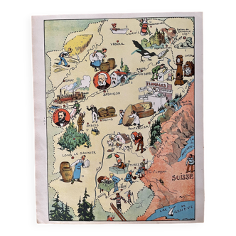
Old map of Limousin, illustrated by Jacques Liozu for Odé Paris publishing house, printed in France in 1951. Pretty illustrations representing historical figures, gastronomic specialties, know-how, French craftsmanship and heritage, historical monuments. Dimensions: large format on thick paper 53 by 37 cm. Poster to frame. Vintage decoration for guest house, country house, vacation home, restaurant, hotel: geography wine wine cheese cathedral castle architecture church Tulle Limoges Guéret Boussac Bellac
Ref. : 4YX48D74
- Dimensions :
- H53 x W37
- Color :
- multicolour
- Material :
- paper
- Style :
- vintage
4.97 ()
Our suggestion of similar items
Discover more similar items


Return your item within 14 days
Cherry-picked items
Carrefully selected sellers
100% secured payment