


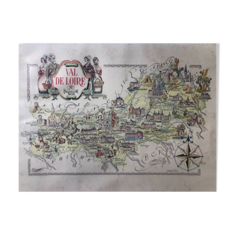
Old Languedoc map illustrated Jacques Liozu 1951
- Great deal
- H37 x W53
- paper
- multicolour
4.97 ()
Description
Old map of languedoc, illustrated by jacques liozu for odé paris publishing house, printed in france in 1951. Pretty illustrations representing historical figures, gastronomic specialties, know-how, french craftsmanship and heritage, historical monuments. Dimensions: large format on thick paper 53 by 37 cm. Poster to frame. Vintage decoration for guest house, country house, holiday home, restaurant, hotel: geography france garonne toulouse albi carcassonne narbonne montpellier nîmes millau aveyron uzès ales florac mediterranean south florac le puy auvergne.
Ref. : VFZYEYX8
- Dimensions :
- H37 x W53
- Color :
- multicolour
- Material :
- paper
- Style :
- vintage
4.97 ()
Our suggestion of similar items
Discover more similar items


Return your item within 14 days
Cherry-picked items
Carrefully selected sellers
100% secured payment