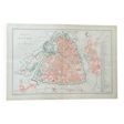
Old map of Lille in the 19th century
- Dimensions :
- H31 x W46 x D1
- Color :
- multicolour
- Material :
- paper
- Style :
- vintage
Original old plan dating from 1883 31x46cm this is indeed an old original document and not a reproduction. 📦 shipped flat folded on itself between several layers of cardboard in order to make the package unfoldable, this type of old document cannot be rolled. Original central fold is hardly visible once unfolded see photos. Do not hesitate to contact me to make a batch to save on shipping costs: for maps and lithographs you only pay one shipment. Old plan of lille detailed plan of **lille**, illustrating the city at a time when its urban organization was still largely marked by its fortifications. The layout of the ramparts, with its characteristic bastions, is well highlighted, recalling the strategic role of the city. Produced in several shades of red, green and black, this document distinguishes the buildings, the communication routes, the public spaces and the defensive elements. The vauban citadel, a central element of the military system, stands out in particular, surrounded by its moats and advanced works. This plan allows us to appreciate the structure of the city before its modern expansion, with a dense network of streets and a high concentration of public and religious buildings. It is a beautiful collector's and decorative object, ideal for fans of cartography, military history and lille's heritage.
5 ()